Apply Deposits Batch Process
Overview
T/C
101-ar-bp-005
 (0 votes, average: 0.00 out of 5)
You need to be a registered member to rate this.

T/C
101-ar-bp-005
(0 votes, average: 0.00 out of 5)
101-ar-bp-006
(0 votes, average: 0.00 out of 5)T/C
101-ar-bp-007
(0 votes, average: 0.00 out of 5)T/C
101-ar-bp-008
(0 votes, average: 0.00 out of 5)T/C
101-ar-bp-009
(0 votes, average: 0.00 out of 5)The Govern suite of applications is regularly being improved upon. Modules and applications are enhanced based upon user requirements and feedback. Govern development is under the direction of R&D and the Govern Road Map offers a insight to the benchmarks, direction, and vision, for development.
| NOTE: The Govern Road Map is subject to changes. |
Click the image below to view the Road Map that was updated August 9, 2018. For further details please contact Govern R&D. If you have access to Confluence click here.
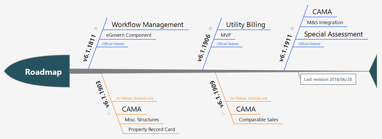
Roadmap Changes (2018/06/28) Roadmap Changes (2017/09/08) Roadmap Changes (2017/08/04) Spreadsheet v1809 Progress Report Road_Map
Upgrade Plan
 (0 votes, average: 0.00 out of 5)
You need to be a registered member to rate this.![]() Loading...
Loading...
This is the landing page for all supported system options including e-Government and Mobile applications.
The Govern Public Web Portal is an e-Government services application that contains a set of modules that provide citizens and professionals public access via the Internet in order to apply, query, request and view information. The ability to make online transactions regarding permits, inspections, real property tax, utility billing, tax assessment, personal property, special assessment, complaints status and multimedia documents brings a new level of efficiency to managing a jurisdiction’s information.
The eGovernment option contains a set of modules that provide citizens and professionals public access via the Internet in order to apply, query, request and view information. The ability to make online transactions regarding permits, inspections, real property tax, utility billing, tax assessment, personal property, special assessment, complaints status and multimedia documents brings a new level of efficiency to managing a jurisdiction’s information.
Click here for more information on the e-Gov page …
The Govern Mobile option allows your assessors, auditors, inspectors, and code enforcement officers to increase productivity by extending processing capabilities to the field. With mGovern, your staff can input results in real-time and immediately update the database with an available connection or work offline until connection is established. mGovern provides the same features and benefits as our desktop modules, including property searches, drill-down capabilities, GIS mapping, and CAMA valuations.
Click here for more information on mGovern – Your Mobile Solution
From the start, knowing the value GIS brings to local government and citizens, GIS integration has played a big role in the Govern philosophy of having a centralized, land-based, property control data model. Over time, driven by the evolution of our GIS partners and our client needs, we have integrated different GIS engines [systems] and developed GIS [applications] or tool boxes.
For integrators, Govern provides a Property Control/GIS API for system interaction and specific property control tasks such as split merges, property area code updates (zoning, districts…), etc.
Click here for Govern GIS Integration …
Click here for MATIX integration
200-options
(0 votes, average: 0.00 out of 5)