MA – Valuation Business Rules

Mass Appraisal Valuation Business Rules

Release 6.1 [In Development]

Overview

The following information provides the computation business rules.

Computation Trigger Business Rules

Computation occurs:

  • On Save in Govern
  • On Condition in the Batch Compute:
    • If modif stamp of detailed record different than detail record modif stamp
    • If force compute of components selected in the batch process
    • If roll forward to other years
  • if MA Audit record is Finalized

Computation does not occur:

  • If Parcel Inactive – MA Records are deleted when inactivated
  • if Building inactive
  • if Parcel Linking inactive
  • if Building Linking inactive for the other linked buildings

History Only

  • If the history only is set to true (-1 or 1), it will be skipped when the computation is done using the Batch Computation program.
  • It will be ignored when a record is saved and computation will occur.

Parcel Linking

A parcel can receive values from other parcels or provide a portion of its value to others. Contrary to the VB6 version, we will only load the values provided by other parcels and it is assumed the parcels that are providing the values have been previously computed.
If possible, if the parcels to be loaded have a MA_MASTER.MODIF_STAMP set to NULL, we should be calling this compute (recursive call) for these parcels prior to complete this step. (to be verified)

IMPORTANT: A parcel cannot receive and provide a value at the same time. Parcels having the MA_MASTER.exclude_from_roll = <> 0 are providing values to other parcels and therefore they are not computed. However the modif stamps to all linked parcels are reset.
  • MA_MASTER.exclude_from_roll = -1 – The parcel provides all types of values to other parcels
  • MA_MASTER.exclude_from_roll = 1 – The parcel provides only a land value to other parcels (to be validated)
  • MA_MASTER.exclude_from_roll = 2 – The parcel provides only a misc. and a building value to other parcels.

Troubleshooting of Computation Errors

In case of errors during the computation process (for example, parameters not configured), all the system columns will be set to 0 and no timestamp will be attached to the appraisal records. (verify if at detail level only?)

TIP: Setup the console

Rounding Business Rules

101-ma-brules-maround-visual.pngGeneral Rounding Method

OpenForms uses the standard Microsoft XXX rounding methodology.
Full column precision for type and sized is used at the database level

Appraisal Rounding Parameters

The following parameters impact rounding at different levels:
Final Appraisal Values
MA Round Table [ma_round]

  • Building, Land, Misc, Income, MRA [code = bldg., inc, land, misc, mra, sale]
  • Total Property Value [code = appval]

General Tax Parameters

  • Personal Property Round Total or Detail value

Linked Records

  • MA_SITE.LK_LAND_VALUE is rounded based on the MA_PARM_MAROUND information (code = ‘land’) – (to be validated)
  • MA_SITE.LK_LAND_AG_VALUE is rounded based on the MA_PARM_MAROUND information (code = ‘land’).
  • MA_SITE.LK_MISC_VALUE is rounded based on the MA_PARM_MAROUND information (code = ‘misc’).
  • MA_SITE.LK_BLDG_VALUE is rounded based on the MA_PARM_MAROUND information (code = ‘bldg’).
  • MA_SITE. LK_INC_GRM_VALUE is rounded based on the MA_PARM_MAROUND information (code = ‘inc’).
  • MA_SITE. LK_INC_DIR_VALUE is rounded based on the MA_PARM_MAROUND information (code = ‘inc’).
  • MA_SITE. LK_MRA_VALUE is rounded based on the MA_PARM_MAROUND information (code = ‘mra’).
  • MA_SITE.PP_LK_VALUE is rounded to 0 decimal.
  • MA_SITE. LK_COMP_VALUE is rounded based on the MA_PARM_MAROUND information (code = ‘compval’).

Detail Component Values

MA Round Table [ma_round]

  • Building Area
  • Building Look-up Area
  • Market Living Area [code = lareamk]

General Appraisal Parameters

  • Quality Points number of digits
  • Building Size
  • Land? (verify)
  • Drawing Area Code Rounding (deprecated in 6.1)

Field Level

  • Column precision and size


See Also


101-ma-values


0 votes, average: 0.00 out of 50 votes, average: 0.00 out of 50 votes, average: 0.00 out of 50 votes, average: 0.00 out of 50 votes, average: 0.00 out of 5 (0 votes, average: 0.00 out of 5)
You need to be a registered member to rate this.
Loading...

MA – Specifications

Mass Appraisal (MA) SPECIFICATIONS

General Information

The following documentation is for version 6.1 only and is intended for information only.

Appraisal Totals

The Property Total value depends on:

  • The valuation method in used for the property.
  • An Override Value – if Effective Override Record
  • Linked Parcels Value Distribution (condos..)

The Site Total value depends on:

  • The sum of characteristics linked to a site

The Detail Record Total value depends on:

  • The cost calculation configuration that can vary by property types, models, etc.
  • Override value in effect


101-ma-Specification


0 votes, average: 0.00 out of 50 votes, average: 0.00 out of 50 votes, average: 0.00 out of 50 votes, average: 0.00 out of 50 votes, average: 0.00 out of 5 (0 votes, average: 0.00 out of 5)
You need to be a registered member to rate this.
Loading...


MA – MA Land Overview

CAMA Mass Appraisal Land Overview

Overview

All CAMA Land information is presented on a single data entry form in Govern OpenForms: this form is called Land Information. By default, this form is integrated with the Govern Property Control Legal Information form. The parcel dimensions, including lot size, total size, front, depth and number of units are maintained on the CAMA Land Information form. The update to the Legal Information form is automatic.

For more information about the Legal Information form, refer to the Govern Property Control section of the Knowledge Base.

The Land Value is determined by a number of factors that include the parcel size, the land use, the rate schedule, adjustments, and tax exemptions applied specifically to the land. A separate rate can be applied for agricultural land on the parcel. Multiple adjustments can be applied.

You can create multiple Land Information records for a parcel in order to cover all the different land uses and types.

The Land Value can be applied to the MRA record or to the Income record, according to the appraisal method that is selected.

The CAMA Land administrative and user forms are used for maintaining the appraisal information associated with the CAMA parcel record.

The administrative setup for this form is performed in Govern Admin in Govern for Windows where you need complete the Mass Appraisal General Parameters for Land and the following Mass Appraisal Validation Tables:

  • Land Adjustment
  • Land Rate Schedule
  • Land Use

Before completing these tables, complete the general CAMA setup as described in the Govern CAMA General Information documentation.

Administrative Overview

This section provides an overview of the required administrative setup for the Mass Appraisal land functions. The setup includes the land parameters on the Mass Appraisal General Parameters form and the Mass Appraisal validation tables and codes for land data; these include the Land Adjustment, Rate Schedule and Land Use validation tables.

Mass Appraisal General Parameters

The Mass Appraisal General Parameters form includes the following options for applying land adjustments and rates:

  • Associate Land Adjustment to Land Uses
  • Associate Land Adjustment to Land Schedules
  • Cumulative Land Rate

See Mass Appraisal General Parameters.

Mass Appraisal Land Adjustment Validation Tables

The following tables are provided for land adjustments:

  • Adjustment Element Category
  • Feature Element Category
  • Header Element Category
  • Rate Adjustment Element Category

See Mass Appraisal Land Adjustment Validation Tables.

Adjustment Element Category

The Adjustment Element Category validation tables are used for the various types of adjustments that can be used with land records; for example, you could set up adjustments based on acreage, location or topography. See CAMA Adjustment Element Category Validation Table.

Feature Element Category

The Feature Element Category validation table is used for adding a description to the Adjustment grid of the Land Appraisal Information form in Govern. This table is provided for informational purposes only. See Land Adjustment Validation Tables: Feature Element Category.

Header Element Category

The Header Element Category is used for displaying a topic heading for the Land Adjustment tables listed on the Land Appraisal Information from in Govern. See Header Element Category Validation Tables.

Rate Adjustment Element Category

The Rate Adjustment Element Category is used to modify the land rate according to user-defined specifications such as soil condition, slope or other geographical features. See Rate Adjustment Validation Codes.

Mass Appraisal Land Rate Schedule Validation Table

The Land Rate Schedule validation table is used for setting up a rate schedule for the Land Value calculation. You can use this table to define fixed rates or to set up a series or rates per unit. You can define a separate Agricultural Rate on this table. See Land Rate Schedule Validation Table.

Mass Appraisal Land Use Validation Table

This Land Use validation table form is used for defining codes by land use; for example Wasteland, Residential or Agricultural. See Land Use Codes Validation Table.

All land records are maintained on a single data entry form called Land Information. The appraised land value is determined from the values entered on this form that include area, use, and applicable adjustments.
This Land Information form has a General and an Adjustments tab. If the Govern Real Property TAX module is integrated to the Mass Appraisal through Govern Admin, an Exemptions tab is included and you can apply tax exemptions directly to the land record. Similar functionality is added to the Building Structural Elements and Features and Miscellaneous Structures forms.

Before recording the land appraisal information record for a property, update the following:

  • Mass Appraisal Site Information
  • Mass Appraisal Property Information
  • Legal Description


101-ma-land


0 votes, average: 0.00 out of 50 votes, average: 0.00 out of 50 votes, average: 0.00 out of 50 votes, average: 0.00 out of 50 votes, average: 0.00 out of 5 (0 votes, average: 0.00 out of 5)
You need to be a registered member to rate this.
Loading...

MA – Product Map

Mass Appraisal Product Map

Overview

The goal of the Product Map is to provide links to existing Mass Appraisal informational pages.
Grouped around the Form Functionality or other stand-alone OpenForms Component ( Batch Process, Report, View, etc.)

Business Rules

OpenForms Govern Standards & Property Control Mass Appraisal Mass Appraisal Conversion
Database/Naming Standards
Number Format Editor
Integrity Business Rules (Active/Inactive)
Frozen ID/Roll Forward Split Merge
Jurisdictions
MA Tables Rules LookUp Groups
Validation Tables MA Values Rules
MA Modif Stamp
MA Compute Entity Configuration
Convert Mass Appraisal Parameters
Convert Mass Appraisal Tables
Convert Standard Formulas to Expressions


Parameters and Tables

Section Product Code MA Tables Options MA Tables Business Rules Other Information Basic Tables
General Parameters &
Table Standards
103-ma-parm-General Parameters
103-ma-parm-Tables
Appraisal Link Group
Look-up by Matrix
Links , Average & Group Option
Unit/Area Lookup, ISRequired , Forced and Display
Allow Table Sequences to use the same column by model
MA Tables BRules 103-pc-tables-jurisd
103-ma-tables-method
103-ma-tables-permadjreason
Mass Appraisal General Tables 103-ma-tables-nbhd
103-ma-parm-Tables-Depreciation
103-ma-parm-Tables-Rounding
103-ma-tables-multdist
103-ma-tables-l_assmt
MA Single Table Category All
MA Tables – Depreciation
MA Single Table Category All – Rounding
MA Single Table Category All – Correlated Values
MA User Table – Limited Assessment


Form Functions

Section Product/Wiki Code Description Specification/Parameters Supporting Info R&D Technical Info/Test Plan
Property Master
(frm-014)
101-ma-frm-014
101-pc-frm-012
101-pc-frm-017
101-pc-frm-018
101-ma-compute-Global
CAMA Property Information (Master)
PC Parcel
PC Area
PC Legal
Compute Total Values for the Property
Global Property Compute
103-ma-tables-method
103-pc-tables-jurisd
103-pc-tables-neighborhood
103-ma-tables-l_assmt
103-ma-tables-multdist
same
101-ma-frm-071 CAMA Property Info Combined (Custom)
includes: Area and Legal
-Audit – 101-ma-frm-019 CAMA Audit Information 103-ma-tables-maactv (activity)
103-ma-tables-maentry (entry)
103-ma-tables-mainfsrce (source)
103-ma-tables-adjtp (adj type)
103-ma-tables-ma_over (ov type)
101-ma-frm-019-Test (6.1)
-Exemption – 101-ma-frm-022 CAMA Exemptions See Roadmap
– What If – 101-ma-frm-030 CAMA What IF (new) Same tables as audit
Value Override
(frm-021)
101-ma-frm-021 CAMA Value Override See Roadmap 103-ma-tables-maover (ov type)
– Site –
(frm-016)
101-ma-frm-016 CAMA Site Info. Site Adjustment Computation
Site Setup(Dev)
103-ma-parm-Tables-Sites
101-ma-frm-016 Form Setup (6.0)
101-ma-frm-016-TestPlan
101-ma-frm-016-UseCase
– Land –
(frm-017)
101-ma-land
101-ma-compute-LandUnit
101-ma-compute-Land
101-ma-frm-017
General Land Information
Compute Land Units
Comnpute Land Value
CAMA Land Information
Compute Land Units
Compute Land Values103-ma-parm-General-2
103-ma-parm-LandUse
103-ma-parm-LandSchedule
103-ma-parm-PlotUse
103-ma-parm-Tables-LandAdjust
101-ma-frm-017 Form Setup (6.0)
101-ma-frm-017-Test Plan
101-ma-frm-017-Use Case
(needs to be updated)
need to review Form Setup
101-ma-frm-032 CAMA Land Ag. (NY)
101-ma-frm-061 CAMA Land Ag. (PA)
– Buildings
(frm-025)
101-ma-buildings
101-ma-compute-Bldg
101-ma-frm-025
General Building information
Compute Building Information
CAMA Building Information
Compute Building Value
103-ma-parm-General-2
103-ma-parm-BldgUse
103-ma-tables-submodel
101-ma-frm-025 form Setup (6.0)
101-ma-frm-005 CAMA Building Drawing 101-ma-frm-005 Form Setup (6.0)
101-ma-frm-012 CAMA Building Area 101-ma-frm-012 Form Setup (6.0)
101-ma-frm-026 CAMA Building Structural Elements BSE 103-ma-parm-Tables-BSE
103-ma-parm-Templates-BSE
101-ma-frm-026 Form Setup (6.0)
Story #10-(4 Dimension Table)
101-ma-frm-026-TestPlan
101-ma-frm-026-UseCase
Misc. Structure – 101-ma-compute-Misc
101-ma-frm-020
Compute Miscellaneous Structure Value
CAMA Miscellaneous Structure
see Roadmap Requirement 14790
Compute Miscellaneous Value 101-ma-frm-020 From Setup (6.0
– Sales & Comps- 101-ma-sales
101-ma-frm-015
General Sales Information
CAMA Sales
101-ma-frm-029
101-ma-compute-Comps
CAMA Comparable Sales
Compute Comparable Sales
– Parcel Linking – 101-ma-frm-003
101-ma-compute-MA-Linking
CAMA Appraisal Linking (Condo +) 103-ma-parm-
101-ma-compute-MA-Linking
– Income – 101-ma-frm-023
101-ma-frm-023-fea-001
103-ma-parm-income
103-ma-parm-add
103-ma-parm-incqua
103-ma-parm-incadj
103-ma-parm-Tables-incitem
103-ma-parm-Tables-incexp
103-ma-parm-Tables-incsbcat
103-ma-parm-incmodel
CAMA Income
CAMA Income – Apply Default Economic model
MA Tables Single Entry – Income Category
MA Tables Single Entry – Added Fields
MA Tables Single Entry – Income Quality
MA Tables Single Entry – Income Adjustments
MA Tables Income Rental Items
MA Tables Income Expense Items
MA Tables Income Sub Categories
MA Tables Income Models
101-ma-compute-Income
101-ma-compute-IncomeFields
Income Group
103-ma-tables-incunit (income unit)
101-ma-frm-023-(Dev Only)
101-ma-frm-070 CAMA Income Rental Detail 103-ma-parm-Tables-IncRental
 Multiple Regression Analysis – MRA (Fair Market) – 101-ma-frm-065
101-ma-compute-MRA
CAMA Fair Market Value (Multiple Regression Analysis – MRA)
Compute MRA Fair Market Value
MRA Computation
103-ma-parm-MRAmodel
103-ma-parm-Tables-MRA
101-ma-frm-065-TestPlan
101-ma-frm-065-UseCase
– Personal Property-
(Appraisal opt.)
– Discontinued – 101-ma-frm-004 CAMA Drawing (non apex)
101-ma-frm-057 CAMA Multiple Assessment Rate
101-ma-frm-059 CAMA SAMA Summary Values
101-ma-frm-078 CAMA Property Distance Weight
101-ma-frm-099 CAMA Value History
3rd Party Integration
Apex Building Drawing 303-apex
Marshall & Swift (Requirement )

Tags: [101] [ma] [ma-frm]

Standard Features (fea)

Mass Appraisal

Status Product Code Appraisal Specific Additional Information Developer Test Plan
101-ma-fea-001 Full Compute Controller/Action Button if manual 101-ma-fea-001 101-ma-fea-001
101-ma-fea-004 Dynamic e-search – Appraisal Dynamic e-search – STD
[To be verified] 101-ma-fea-010 Freeze & Audit
101-ma-fea-011 Roll Forward Business Rules
101-ma-fea-006 Saved Datasets
101-ma-fea-017 Audit Trail


Batch Process (bp)

Module Wiki Page Batch Process Name Batch Process Name GFW Process Test Plan
std 101-std-bp-001 Evaluate Expressions (Recompute) co_ (pcode).s01-c.all
ma 101-ma-bp-001 Import APEX area codes ma_impapexsketc [to be verified]
ma 101-ma-bp-002 Mass Appraisal Batch Compute ma_compute Developers Page
ma 101-ma-bp-003 Finalize Assessment Close Year (History = yes) ma_closeyear
ma 101-ma-bp-004 Batch Update ma_batchUpdate see Roadmap
ma 101-ma-bp-005 Batch Computation of Sales ma_salescompute Developers Page
ma 101-ma-bp-006 Transfer Appraised Value to Real Property Tax ma_trnstotax see Roadmap
ma 101-ma-bp-007 Generate Audit Pending ma_auditpending change long description to MA (currently listed as Real Property)
ma 101-ma-bp-008 Generate Audit Finalize ma_auditfinalzd change long description to MA
ma 101-ma-bp-012 Comparable Sales Extract to be defined see Roadmap
pp 101-pp-bp-001 Personal Property Computation pp_compute see Roadmap
ma 103-ma-bp-005 Copy Mass Appraisal Parameter Tables to Year ma_copy GA1609
ma 103-ma-bp-006 Initialize Mass Appraisal Next Year Data ma_init_year
ma 103-ma-bp-010 Marshall And Swift – Copy To Year ma_ms_copy_year


GNA Administrator

Application Parameters

Mass Appraisal

Status Wiki Page Name Notes Test Plan
001 GENERAL PARAMETERS
103-ma-parm-General-1 001 General Parameters – Page 1 Will be reviewed to remove unused parameters
103-ma-parm-General-2 001 General Parameters – Page 2
103-ma-parm-General-3 001 General Parameters – Page 3
103-ma-parm-General-4 001 General Parameters – Page 4
103-ma-parm-General-5 001 General Parameters – Page 5
[roadmap] 103-ma-parm-General-6 001 General Parameters – Page 6 Marshall & Swift
[to be verified] 103-ma-parm-Appraisers 002 MA APPRAISERS
103-ma-parm-Tables-MASTER 003 MA TABLES (Master)
103-ma-parm-Tables-Single 004 Tables – Single Entry
103-ma-parm-Tables-BSE 005 Tables – Building Structural Elements
103-ma-parm-Tables-Depreciation 006 Tables – Depreciation
103-ma-parm-Tables-IncExpense 007 Tables – Income Expenses
103-ma-parm-Tables-IncRental 008 Tables – Income Rental Details
103-ma-parm-Tables-LandAdjust 009 Tables – Land Adjustments
103-ma-parm-Tables-MRA 010 Tables – MRA
103-ma-parm-Tables-COMPS 012 Tables – Comparable Sales Elements
103-ma-parm-Tables-Sites 013 Tables – Sites
103-ma-parm-Templates-BSE 050 BSE Templates
103-ma-bp-005 Copy to Year Copy Mass Appraisal Tables to Year
103-ma-bp-006 Initialize to Year Copy Mass Appraisal Data to Year

See GNA Product Map


101-ma-map


0 votes, average: 0.00 out of 50 votes, average: 0.00 out of 50 votes, average: 0.00 out of 50 votes, average: 0.00 out of 50 votes, average: 0.00 out of 5 (0 votes, average: 0.00 out of 5)
You need to be a registered member to rate this.
Loading...

MA – Module OpenForms Reference

Mass Appraisal Module OpenForms Reference

Release 6.1 [To be reviewed]

Overview

OpenForms Reference information. Intended for Business Analysts and System Administrators.
The page contains general information on the system standards queries and distributed forms.

Distributed Forms

The following forms are distributed via the Enterprise Migration Tool EMT Import/Export in the Utility menu in the OpenForms Govern’ Administrator (GNA) system.
The forms can be copied and modified in the OpenForms Designer (OFD).


Form No. Page Link/Product Code Description
MA017 101-ma-ofr-017 CAMA – Land
MA021 101-ma-ofr-021 CAMA – Value Override
MA015 101-ma-ofr-015 CAMA – Sale info
MA014 101-ma-ofr-014 CAMA – Property Info
MA 101-ma-ofr- Buildings (contains BSE and )
MA 101-ma-ofr- CAMA – Building Drawing
MA016 101-ma-ofr-016 CAMA – Site


Site

[in development]

Business Entity Designer

Model & Entities

  • The Model is CAMA Sites.
  • Business entities include MA_Sites_Values and MA_Sites_History. These entities are linked by P_ID.

Attributes

Three attributes are added to the form in the BED.
These are calculated values that use the following expressions.

  • BUILDING_DIR IsNull(@attrINCOME_DIR_VALUE,0)-IsNull(@attrLAND_VALUE,0)
  • BUILDING_GRM IsNull(@attrINCOME_GRM_VALUE,0)-IsNull(@attrLAND_VALUE,0)
  • BUILDING_MRA IsNull(@attrMRA_VALUE,0)-IsNull(@attrLAND_VALUE,0)
NOTE: The same attributes and entities are added to the CAMA Property Information form.

OpenForms Designer

Controller for Site Information

  • Assembly: MsGovern.OpenForms.CustomControls.dll
  • Class MA_Site_Controller

Site Information > General tab

  • The General tab is configured by a custom control:
  • MASiteAdjustments_Control
  • The control displays a grid used for entering the site adjustments for the site.

Controller for Site History

  • Assembly: MsGovern.OpenForms.CustomControls.dll
  • Class MA_SiteHistory_Controller

Site Information ID Setters

  • P Id Parcel ID
  • Frozen Id Frozen ID
  • Year Id Year ID

Site History ID Setters (to be verified)

  • P Id Parcel ID

Order by

  • Site No Ascending
  • Year Id Ascending
  • Frozen Id Ascending

Land

Model
The Land Information Model Land Information form has two entities:

  • MA_LAND
  • MA_EXEMPTIONS

The exemptions entity is useful if you have real property tax exemptions that can be applied directly to a land record.
Data associated with MA_EXEMPTIONS are saved to MA_LK_EXEMPTIONS

Controllers
MA LAND

  • Assembly: MsGovern.OpenForms.CustomControl.dl
  • Class: MA_Land_Control
  • The Controller has a custom save and delete.
  • The custom save is used for creating the original record (Frozen ID -1)

MA LAND Form Action Buttons

  • Copy Land to copy the land data info from current land record
  • Paste Land to paste the land data info to current land record
  • Refresh to compute data and reload the form

MA_LAND ADJUSTMENT
Custom Entity

  • Assembly: MsGovern.OpenForms.CustomControl.dl
  • Class: MA_LandAdjustments_Control

Buildings

under construction

Reference Database tables
PC_PARCEL_LK_BLDG
MA_BUILDINBG
MA_BUILDING_INFO (merged with MA_BUILDING)
MA_BUILDING_DRAWING
MA_BUILDING_AREA by year
MA_BUILDING_1, _2, _etc.

Data Model

General Information on the models used for the forms

Property Control

Parcel [pc_parcel] is active [effective year, inactive year] Parcel linked to buildings [pc_pid_lk_bid] active [effective and inactive date] Building can be linked to property location (ex: corner address)
Building can be linked to building (ex: unit to condo complex building, premise renting in…)
Building can be master in building link (ex: condo complex building, rental building…)
Occupant records can be linked to building

Mass Appraisal (by year)

Building can be linked to a parcel that is linked to condo appraisal
Building can be linked to a parcel that is linked to premise rental appraisal
Building can be linked to a parcel site record by year
Building can be linked to a parcel income record by year
Building can be linked to a parcel MRA record by year

Miscellaneous Structure records can be linked to building
Occupant records can be linked to building

What’s New

The following are additions and changes related to the CAMA OpenForms Reference:

Release 6.1.1605.245 / 6.1.1603.316

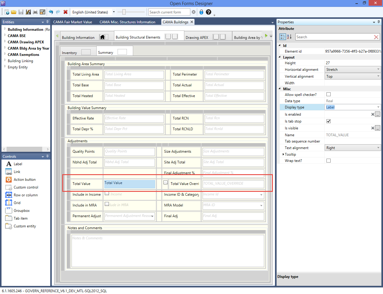
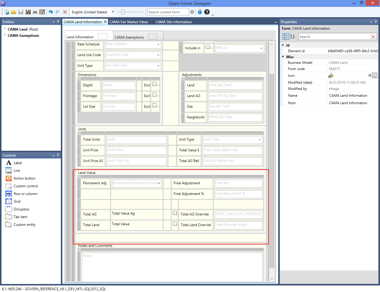
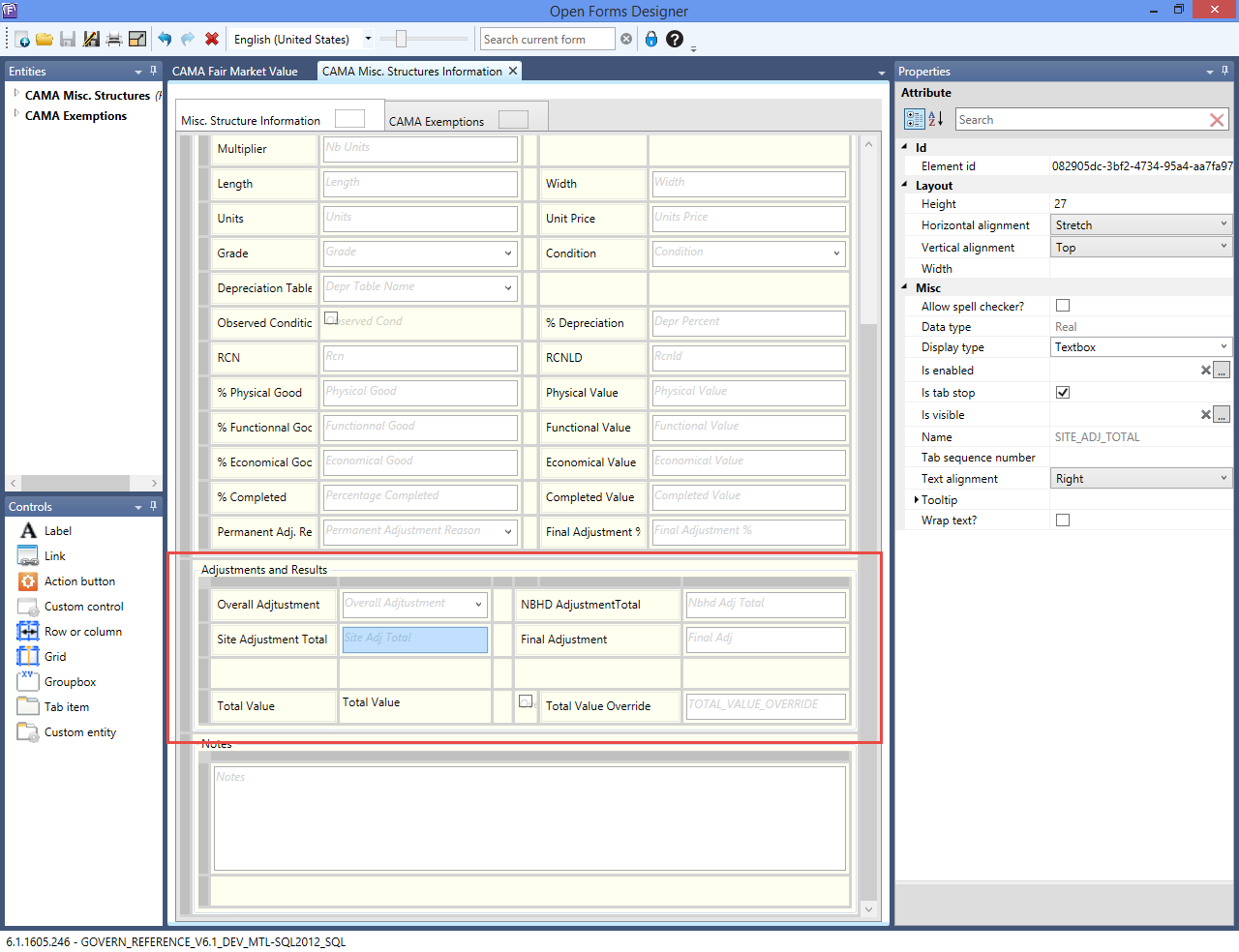
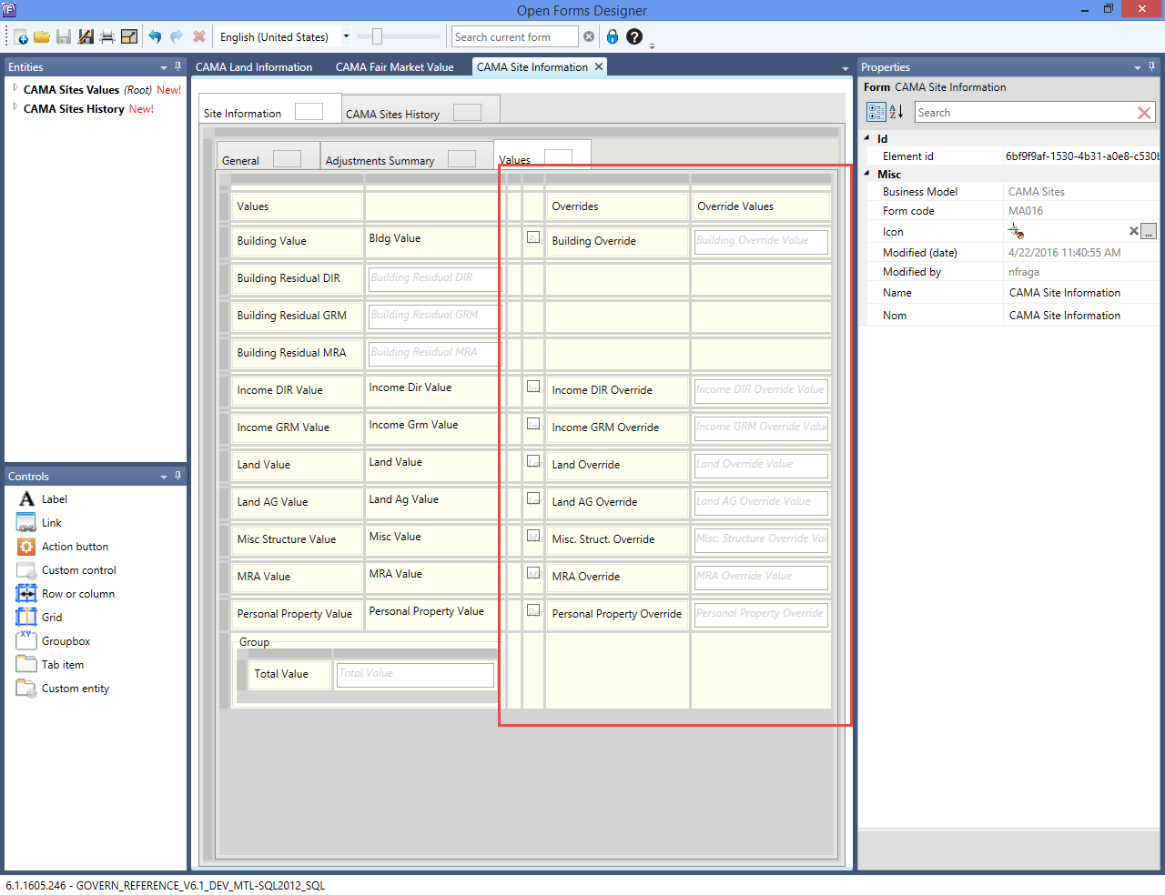
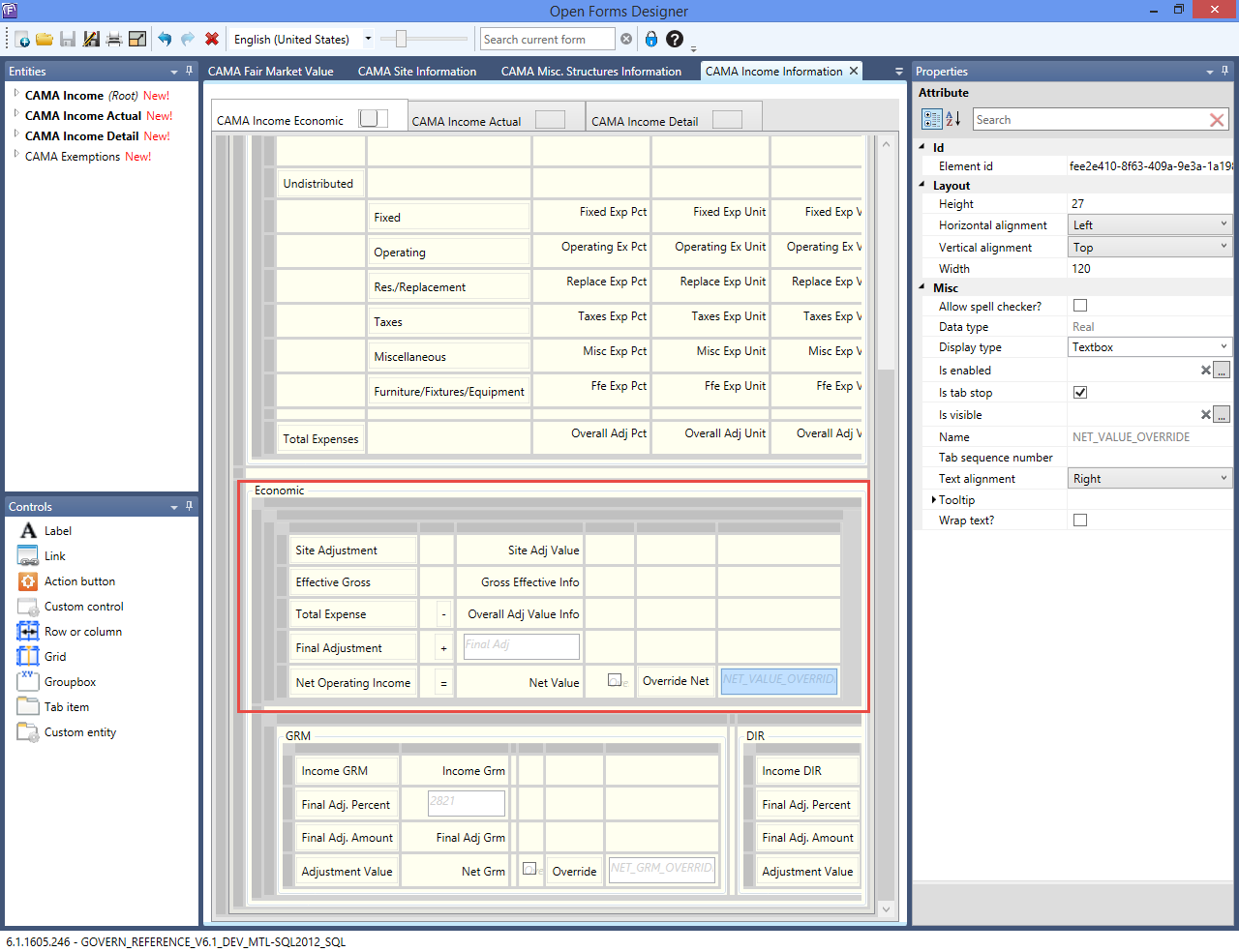
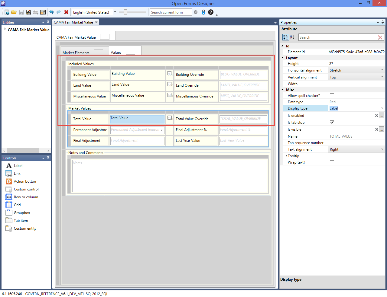
A new field called VALUE_OVERRIDE has been added to the following forms:

  • Buildings
  • Income
  • Misc Structures
  • Site
  • Land
  • MRA

Deployments and Versions affected:

  • GOVERN_REFERENCE_V61_DEV_MTL-SQL2012_SQL 6.1.1605.245
  • GOVERN_REFERENCE_V61_REL_MTL-SQL2012_SQL 6.1.1603.316

Location of the changes are indicated below.

CAMA Buildings

CAMA_Buildings.png
Click to view full size image.

CAMA Land Information

CAMA_LandInformation.png
Click to view full size image.

CAMA Misc. Structure Information

CAMA_MiscStructInformation.png
Click to view full size image.

CAMA Site Information

CAMA_SiteInformation.png
Click to view full size image.

CAMA Income Information

CAMA_IncomeInformation.png
Click to view full size image.

CAMA Fair Market Value

CAMA_FairMarketValue_MRA.png
Click to view full size image.


101-ma-ofr


0 votes, average: 0.00 out of 50 votes, average: 0.00 out of 50 votes, average: 0.00 out of 50 votes, average: 0.00 out of 50 votes, average: 0.00 out of 5 (0 votes, average: 0.00 out of 5)
You need to be a registered member to rate this.
Loading...

MA – Overview of CAMA Tables and Parameters

An Overview of CAMA Tables and Parameters

Overview

This page describes the general setup that is applicable to all CAMA modules: Sales, Land, Buildings, Miscellaneous Structures, and Income. The configuration for the modules is described on separate pages.

What’s New

Govern OpenForms v6 introduces the Govern OpenForms Designer for creating the models for the data entry forms. Because of this, all the CAMA forms have changed. The layout is different from Govern v 5.1. However, all fields are the same.

General Configuration

The general configuration for Govern CAMA comprises:

  • Mass Appraisal General Parameters
  • Mass Appraisal Validation Tables
  • Appraiser’s Name and Address and Report forms
  • Multiple Assessment Rates form

This is described in the Govern General CAMA Administration guide

Mass Appraisal General Parameters

The Mass Appraisal General Parameters form has six pages or tabs with parameters and option for configuring the CAMA data. The default menu items and parameters that are common to all the sub-modules are described in Govern CAMA General Administration guide.

The following parameter types are general:

  • Yearly Data: required for calculating depreciation
  • Neighborhood Adjustment
  • Frozen records
  • Roll forward data
  • Increase / Decrease options
  • Transfer to Tax
  • Marshall & Swift

For information on parameters that are specific to a sub-module, click on one of the following links.

Mass Appraisal Validation Tables

The following Mass Appraisal Validation Tables are used or referenced by several of the sub-modules and are described here:

Depreciation Validation Tables
Use the Mass Appraisal Depreciation Validation Tables and Codes to set up depreciation percentages to apply to building structural elements and miscellaneous structures. Depreciation Tables are a prerequisite for the Building Use Code and Miscellaneous Structures Codes (MUSE) validation tables.

Correlated Values Distribution (or Mixed Distribution) Validation Tables

Use the Correlated Values Distribution table to set up values for CAMA, Comparable Sales, Income (DIR) and Income (GRM) if you are using the Correlated Values method.

Rounding

Use the Mass Appraisal Rounding validation table to define rounding on selected mass appraisal values, such as Building Value, Land Value, and Comparable Value. You can define a different formula, logical expression, or value to round to, 10, 100, etc. for each.

Limited Assessment

The Limited Assessment Mass Appraisal validation table type is used for defining Capped Values. In a year in which property values increase by significant amounts, you can use capped values to prevent an abrupt increase in property taxes. Capped values create an upper limit for property assessments.

Neighborhood

Use the Neighborhood validation table to set up neighborhood adjustments for building, miscellaneous structures, and land records.

Site Information Validation Tables

Use the Mass Appraisal Sites validation tables to set up adjustments according to geographic information, such as proximity to heavy or light traffic, green spaces, or schools. You can apply as many site adjustments as required to a record and even create multiple site adjustments records for each property. Site Adjustments are defined by Land, Miscellaneous, Income, Buildings, or on All values. An add, subtract, divide or multiply operator for the adjustment can be associated with each table.

Appraiser’s Name and Address Records

Use the Appraiser’s Name form to create name and identification records for each appraiser.

Appraisal Report Fields

Use the Appraisal Reports Fields screen to associate Govern fields to fields in the Uniform Residential Appraisal Report (URAR).

Multiple Assessment Rates

Use the Multiple Assessment Rate form to set up varying tax rates according to property type. These values are transferred to the Tax Assessment and Billing subsystem.

Govern CAMA Batch Processes

The Govern CAMA batch processes are run in Govern for Windows with the exception of the Finalize Tax Assessment Roll for Govern CAMA which is run in Govern OpenForms These batch processes are described in full in the Govern CAMA General Batch Processing guide. They include:

Batch Update

The Batch Update process in Govern for Windows updates specified database fields and all applicable parcel records. You can add to or replace existing values and set one or more conditions for the update. A new version of the Batch Update batch process was created for Govern OpenForms. This is described in the Govern General Batch Processing guide.

Appraised Value Computation

This process updates all selected Mass Appraisal values.

Sales Data Computation

The batch Sales Data Computation process is used to re-compute previously entered sales data with the parameters from an alternate year. For example, you can compute the sales data from last year with the parameters for the current year.

Load Apex Images

This process loads images created with Apex to Govern.

Update Drawing Image

This process regenerates the saved drawing images and update the MA_BLG_DRAWING table. Images are saved as bitmaps and added to the database.

Comparable Sales Extract

The Comparable Sales Extract batch process extracts records f a list of comparable properties based on the sales records and the criteria entered in the CAMA Comparable Sales Validation Tables. Extracted records are saved to the following database tables: ma_sale_extract, ma_sale_extract_p, and ma_sale_extract_s. These records are used for comparable sales calculations.

Apply Income Model

This process applies an Income Model to a parcel or range of parcels. Selection is based on a Tax Map Number range or Jurisdiction.

Export to an Appraiser’s Database

Run the Export to an Appraiser’s Database process to extract a copy of a database or a portion of a database, to your computer hard drive. This extracted database can then be copied to a laptop and used by an appraiser out in the field. Alternatively, you can use mGovern – Your Mobile Solution.

Import from an Appraiser’s Database

This process imports the appraiser’s database to the network.

Use an Appraiser’s Database at Next Startup
This process is run to prevent the appraiser from using the live database at the next startup.

Import Marshall & Swift Data

This process imports Marschall & Swift data info Govern.

Finalize Tax Assessment Roll for Govern CAMA

Run the Finalize Assessment Roll batch process to finalize the tax assessment records for a group of parcels or for all parcels.

NOTE: This process is a requirement when you change to a new fiscal year.

This process sets the HISTORY_ONLY field to -1 on the selected parcels in the MA_ MASTER table. This purpose of this History Only record is to retain a copy of all the data for parcel as they were at the time the year was closed. In the History Panel, this record is identified by Frozen ID -1 and assigned the flag, Certified.


101-ma-parameters


0 votes, average: 0.00 out of 50 votes, average: 0.00 out of 50 votes, average: 0.00 out of 50 votes, average: 0.00 out of 50 votes, average: 0.00 out of 5 (0 votes, average: 0.00 out of 5)
You need to be a registered member to rate this.
Loading...

MA – Land Information

Mass Appraisal Land Information

[In Development]

Specification Overview

All the CAMA Land information is presented on a single form in Govern OpenForms called Land Information.

  • You can create multiple Land Information records for a parcel in order to cover all the different land uses and types.
  • Data about the parcel size are maintained on the CAMA Land Information forms and with the Govern Property Control Legal Information form.
    • The update on the Legal Information form is automatic.
    • There are options for excluding the lot size, depth, and frontage for a specific parcel.
    • For more information about the Legal Information form, click on the following link: PC Legal Information
  • The Land Value is determined by a number of factors that include the parcel size, the land use, the rate schedule, adjustments, and tax exemptions applied specifically to the land. It can be applied to a MRA record or to a Income record, according to the appraisal method selected as well as to the land record’s option INCLUDE IN Income or MRA.
  • Assessment Exemptions can be applied on Appraisal Land Records
  • Audit, Copy to, Roll forward, Audit trails and other standard features

What’s New

[5.1] (to be verified in 6.0) You can now copy and paste a land record. This can save time if you are creating multiple land records that are similar. The land records can be on separate parcels. All data from the General tab can be copied with the exception of the LOT_SIZE, LOT_UNITS_TYPE, UNITS, and UNITS_TYPE. Data are copied one record at a time.
[6.1] Refresh Icon no longer available
[6.1] Mass Appraisal Link Group table lookup …
[6.1] Cluster configuration for table lookup …
[6.1] Site is required for all components
[6.1] Land Info merged into Land
[6.1] Simulation and template fields removed
[6.1] New Override Fields (to show calculated and overrided value)

Land Information

General

All land records are maintained on a single data entry form called Land Information. The appraised land value is determined from the values enteredon this form that include area, use, and applicable adjustments. This Land Information form has a General and an Adjustments tab. If the Govern Real Property TAX module is integrated to the Mass Appraisal through Govern Admin, an Exemptions tab is included and you can apply tax exemptions directly to the land record (verify if available in 6.1) . Similar functionality is added to the Building Structural Elements and Features and Miscellaneous Structures forms. Before recording the land appraisal information record for a property, update the following:

  • Mass Appraisal Site Information
  • Mass Appraisal Property Information
  • Legal Description

If multiple Land Information records are available for the property, the navigation arrows are displayed. If it is configured, the Record Description is displayed.

Land Schedules without a Predefined Price per Unit

If a price per unit is included in the rate schedule, the land value is calculated automatically. Otherwise, if a price per unit is not included, then you must enter a value in the Units Price field under section. The Land Value is calculated based on the unit price and other fields.

Calculating the Agricultural Value

The Agricultural Unit Price is separate from the Land Unit Price. It is determined by multiplying the Units * Unit Price AG. The Land Adjustment is calculated according to the configuration. Amounts are displayed in the Unit Price AG and Total AG Before Adj. fields if the selected rate schedule code applies to the agricultural value.

The Units Price and Total Value Before Adjustments are calculated based on the Rate Schedule Code. The Total Value field at the bottom of the interface is calculated based on the total with the adjustments.

Excluding Land Area from the Legal Description

To exclude the land size from the Legal Description record for the property click on the exclude option according to how you set up the record:

  • Exclude Lot Size
  • Exclude Depth
  • Exclude Frontage

Copy and Paste to Create New Land Records

  • Copy: Use the copy and paste icons to copy data from one land record to another. The records can be on the same parcel or on multiple parcels. This can be useful if you are creating multiple land records with similar data. Records are copied one by one. To copy a record, open it in the Land Information form and click the Copy icon.
  • Paste: Use the Paste icon to paste land information data from the source parcel where it was copied with the Copy icon to the destination parcel. All data from the General tab are copied with the exception of the following: Lot Size, Lot Units Type, Units, and Unit Type (validate).

Overriding the Land Value

Total Value = Units * Unit Price + Land Adjustment + Site Adjustment + Neighborhood Adjustment + Final Adjustment.

To override the Total Value:
1. Select the General tab on the Land Information form.
2. Select the Override option to enable the Final Adjustment field.
Enter a new value in the Final Adjustment field. This is added to the Total Value. (New change in 6,.1)

Land Form – General

–General Section
Site No.

  • Select the Site from the Site No dropdown list. Several sites can be created for a property on the MA – Sites form. Typically, they are based on location and other geographic information.
  • Multiple adjustments can be applied to each Site using the MA – Sites form.

Rate Schedule

  • Select a land rate schedule from the Rate Schedule dropdown list. Rate Schedules are defined in Govern Admin. They determine the land value based on a number of factors, such as the number of units, the Link Group type (neighborhood, jurisdiction, income neighborhood). The rate can be applied as a flat rate or according to a schedule. A separate rate expression can be applied on the agricultural land on the parcel. The Land Adjustments can be associated with Rate Schedules in Govern Admin.

Land Use Code

  • Select a code for the land use from the Land Use Code dropdown list. The Land Use Codes are defined in Govern Admin. They are used for classifying properties according to how the land is used. Land Use Codes can be associated with a Property Type (VT_USR PROPTYPE) and classified as Agricultural. The Land Adjustments can be associated with land use codes in Govern Admin.

Land Unit type

  • Select the unit type corresponding to the area you entered from the Lot Units Type dropdown list. Examples are acres, hectares, square feet, and square meters.

–Dimensions Section
Enter the area of one of the following:

  • Depth / Exclude
  • Frontage / Excluded
  • Lot Size / Exclude

Exclude is used for calculating the land value. If Exclude is checked, the area will not be used in the Legal Total Size calculation.

–Units Section
During the computation, the units and unit type are automatically converted and the results are displayed in the Units and Unit Type fields. The Units Price and Total Value Before Adjustments are calculated based on the Rate Schedule Code during the save. The Total Value field at the bottom of the interface is calculated based on the total with the adjustments.

Total Units

  • Calculated amount

Unit Type

  • Calculated field (converted)

Unit Price

  • Calculated amount if entered in Land Schedule Land Rate

Unit Price AG

  • Calculated amount if entered in Land Schedule AG Rate

Total Value Before Adj.

  • Sum of land value before adjustments. Calculated amount.

Total AG Value Before Adj.

  • Sum if land Agricultural values before adjustments. Calculated amount.

–Adjustments Section

Land

  • The Land Adjustment is the total of the adjustments selected on the Adjustments tab. Calculated amount

Land AG

  • Calculated amount

Site

  • The Site Adjustment is calculated according to the selections made on the Site Information form. Calculated amount

Neighborhood

  • The Neighborhood Code is selected for the property on the Property Area record. Refer to the Property Control guide for details on this form. The adjustment applied to the land for the Neighborhood is defined in Govern Admin per Neighborhood on the Mass Appraisal Neighborhood Validation Table. .Calculated amount


Land Form – Adjustments

Viewing / Applying an Adjustment

The Land Information Adjustments tab lists the available adjustments.

To apply an adjustment, select the Adjustments tab on the Land Appraisal Information function. The available adjustments are listed. According to the setup, the adjustments can be associated with the Land Use Code or Rate Schedule selected on the General tab. Otherwise, they are not associated with any data entry field.

By default the land adjustments are listed by sequence number. You can sort them in ascending or descending order by any of the available columns. To do this, click on the column heading. You can also remove any columns that you do not want to view. Right-click on the title bar of the columns to display a context-sensitive menu. Deselect the columns that you do not want to view. You can also change the position of a column by dragging and dropping it to the left or right.

Select a specific code for the adjustment type, by clicking inside the Adjustment Code text field, if applicable. Click Save.

Overriding an Adjustment

To override a land adjustment, select the Adjustments tab on the Land Information form. Select (check) the Override checkbox beside the value you want to modify.

Enter a new value in the Value field and click Save. Note: The value is recalculated and displayed under Value.

Land Form – CAMA Exemptions

Validate if available in 6.1

Configuration

For a step by step administrative setup see Module Specification (above) Configuration or Product Map under the Land Form Function for all related product detail wiki URL pages.

There are three (3) Mass Appraisal Validation Tables that are specific to land information. All are set up and maintained in Govern Admin in Govern for Windows.

  • Land Adjustments (Table: MA_PARM_LANDADJT)
  • Land Rate Schedule (Table: MA_PARM_LANDSCHD)
  • Land Use Codes (Table: MA_PARM_LANDUSE)

Land Adjustments

  • You can create as many Mass Appraisal Land Adjustment tables as required.
  • Multiple adjustments can be applied to a land record.
  • Land adjustments tables are defined in Mass Appraisal tables and are often associated with topographic or other geographic features of the land or proximity to roads or schools.
  • They can be applied as flat rates, formulas, or logical expressions and associated with the land use or rate schedule codes.
  • Adjustments are displayed on both the Land Information > Adjustments tab.

Land Rate Schedule

  • The Mass Appraisal Land Rate Schedule Validation Table is unique.
  • Rate Schedules are defined in Govern Admin.
  • They determine the land value based on a number of factors, such as the number of units, the neighborhood, and the jurisdiction.
  • The rate can be applied as a flat rate or according to a schedule.
  • A separate rate, formula, or logical expression can be applied on the agricultural land on the parcel.
  • The Land Adjustments can be associated with Rate Schedules in Govern Admin.

Land Use Codes

  • The Mass Appraisal Land Use table is unique.
  • The Land Use Codes are used for classifying properties according to how the land is used.
  • Land Use Codes can be associated with a Property Type (Table: VT_USR_PROPTYPE) and classified as Agricultural.
  • The Land Adjustments can be associated with land use codes in Govern Admin.
NOTE: Before performing the specific setup for the CAMA Land Information form, it is important to complete the general CAMA configuration.

Documentation

This section provides links to the administrative and user documents for land information.

Administrator
Govern Land Administration : Mass Appraisal General Parameters and Validation Tables (specific to land) 6.0
Linear Square Foot Calculation: [To be revised] This document describes the linear square foot calculation used in the cumulative land calculation method.

User Manual
This document describes the Govern CAMA Land Information form for data entry of land
Govern Land Information user data entry

Technical Specification

See Module Section OpenForms Reference (OFR), Installation and Design info from R&D Developers

Video

8-101-100 – Land Appraisal from the Appraiser’s side Course 1 of 5 Govern APPRAISER
[PDF] [video]


101-ma-frm-017


0 votes, average: 0.00 out of 50 votes, average: 0.00 out of 50 votes, average: 0.00 out of 50 votes, average: 0.00 out of 50 votes, average: 0.00 out of 5 (0 votes, average: 0.00 out of 5)
You need to be a registered member to rate this.
Loading...